Operational area
The office’s operational area includes Beitou, Shilin, Nangang, Neihu District, Taipei City, and Xizhi District in New Taipei City. Geographically it reaches from south of the Datun Mountains to the Keelung River and southeast of Wuzhi Mountain to Nangang Mountain and Xizhi Dajianshan, covering an area from the north end of Taipei Basin to the east northeastern end of the basin.
Mainly located in the Datun Volcanic Group and the Taipei Basin, the area includes three types of topography: mountains, basins and hills. Its slope direction decreases from north to south and west to east. The mountains in the north are volcanic terrain, while the west tends to be mountains arranged in a northeast to southwest direction. The flat land belongs to the alluvial plain formed after the sedimentation of the Great Taipei Lake. Overall, there are extreme changes in terrain.
Climate
On average it rains about 160 days a year in the area managed by the office, with annual average rainfall in excess of 2,200mm. There is spring rain from February to April, plum rain from May to June, summer thunderstorms and typhoon rain from July to September. From October to January the autumn and winter northeast monsoon brings orographic rain.
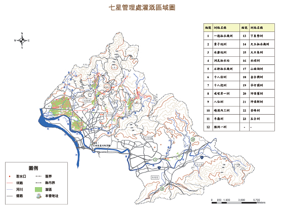
Water sources
Most of the canals in this area take surface water from rivers. In Beitou District, Huang River, Shuimokeng River and Guizikeng River are used as water sources; in Shilin District, Shuangxi River is mainly used as a water source; in Neihu District, Neigou River is used as a water source; in Nangang and Xizhi districts, the water source is partially supplied by the Keelung River, while the rest comes from stored surface runoff water.
Agricultural characteristics
The irrigation areas under the office are distributed across plains and mountainous/hilly terrain. The plains are mainly used for planting rice, with the Guandu Plain the main growing area. Early settlers opened up the mountainous and hilly land, transforming it from gardens to terraced fields for planting rice and nowadays tangerines, strawberries, green bamboo shoots, yams, cold vegetables, flowers, horticultureand other crops. Different types of farms have been developed based on what is grown in each area. In addition to supplying fruit and vegetables, they also provide produce to the greater Taipei Metropolitan Area, a place with functions focused on recreation, education, society and environmental protection.
Canals in this area are all sourced from river surface water. In Beitou District, Huang River, Mokeng River and Guizikeng River are used as water sources. Shilin District mainly uses Shuangxi River as its water source. Nangang and Neihu districts mainly use surface runoff water as a source of agricultural irrigation water. The main irrigation channels are as follows:
- Yide Water Pump Canal
- Guizikeng Canal
- Shuimokeng Canal
- Baxian Canal
- Qilianyi Canal
- Shipai Water Pump Canal
- Zhoumei Water Pump Canal
- Banling Canal
- Shibafen Canal
- Shibawa Canal
- Tianyu Water Pump Canal
- Shanzhuhu Canal
- Xiadongshi Canal
- Houdongyi Canal
- Dashijiao Canal
- Dengfeng Canal
- Pingdingjiu Canal
- Pingdingxin Canal
- Jinhexing Canal
- Yuzaiyuan Canal
- Shuikong Canal
- Huangxineisan Canal
- Wufen Canal